Alibaug Beaches: Kashid, Nagaon, Akshi, Kihim and More, Beach by Beach
Alibaug’s beaches run along the Konkan coast on either side of the town, from Mandwa, where the ferries from Mumbai land, south to Kashid. They are long, flat and backed by trees, better for walking and sunsets than for swimming. This guide goes beach by beach, with road distances measured from Mandwa jetty and from Alibaug beach in town, so you can plan the day around the ferry.
At a glance
| Beach | From Mandwa jetty | From Alibaug town | What it is like |
|---|---|---|---|
| Mandwa | At the jetty | About 20 km | Quiet, with a view back across the bay towards Mumbai |
| Awas | About 8 km | About 17 km | One of the largest and cleanest beaches in the taluka |
| Kihim | About 13 km | About 12 km | Woods, wild flowers, butterflies and birds |
| Varsoli | About 19 km | About 3 km | Just north of town, quieter than Alibaug beach |
| Alibaug | About 20 km | In town | A long, flat walk, with Kolaba Fort offshore |
| Akshi | About 25 km | About 7 km | White sand, trees along the shore, birds |
| Nagaon | About 29 km | About 11 km | The busiest, with boat rides and water sports |
| Revdanda | About 36 km | About 18 km | A village beach by the ruins of a Portuguese fort |
| Kashid | About 50 km | About 32 km | Near-white sand between rocky hills |
Distances are by road, measured on OpenStreetMap.
Getting there
- Catamaran from the Gateway of India: about an hour to Mandwa jetty, with fares of about ₹185 to ₹285 one way depending on the operator and class. The fare includes a bus to Alibaug town, about half an hour more. Life jackets are compulsory. The Gateway boats stop for the monsoon; in 2026 they ran until 26 May and restarted after 31 August.
- Ro-Ro ferry from Ferry Wharf (Bhaucha Dhakka): carries cars and bikes to Mandwa, useful if you want to drive between the beaches.
- By road: the Atal Setu sea bridge has cut the drive from South Mumbai to roughly two hours, depending on traffic.
Our Alibaug guide and the Gateway of India page have more on the ferries.
North of town: Mandwa, Awas and Kihim
Mandwa is where the boats land, a quiet beach surrounded by coconut groves, with a view across the bay towards the Gateway of India on a clear day. Walk it before the boat back.
Awas, about 8 km south of the jetty, is described by the district as one of the largest and cleanest beaches in Alibaug taluka, with the smaller beaches of Saswane, Dighodi and Kolgaon nearby.
Kihim, about 12 km north of town, is known for its woods of wild flowers, butterflies and birds, and its homestays.
In and around town: Varsoli, Alibaug and Akshi
Varsoli is just north of the town centre and calmer than the main beach.
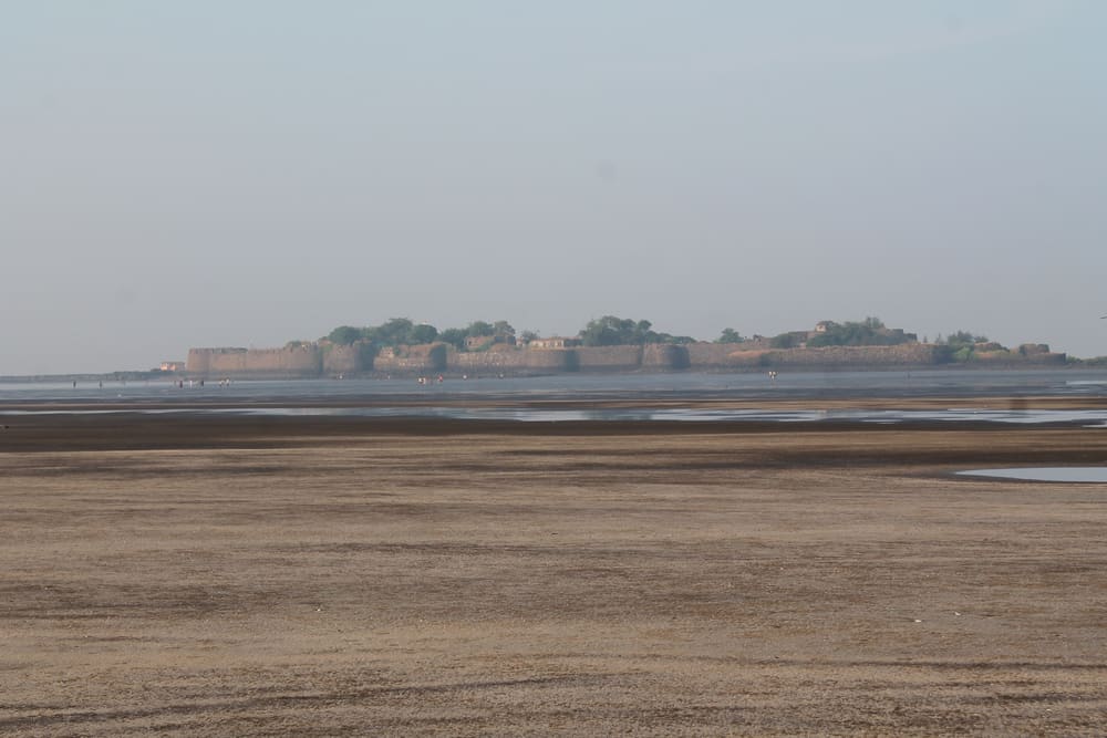
Alibaug beach is a very flat stretch for a long walk. The sand is hard and dark, and the tide comes in from all sides, so you may have to wade back. Offshore stands Kolaba Fort, the Maratha sea fort; at low tide you can walk across the sand to it, but check the tide times and come back well before the water returns.
Akshi, about 7 km south of town, is a white-sand beach with trees along the shore and a fishing village behind it. It is quieter than Nagaon and popular with birdwatchers.
South of town: Nagaon and Revdanda
Nagaon, about 11 km south of town on the road to Revdanda, is the busiest beach near Alibaug, with boat rides, kayaking and other water sports, and holiday cottages behind it. It is the one to choose if you want activity rather than quiet.
Revdanda, about 18 km south of town, is a village on the old Chaul harbour. Part of it lies inside the ruins of Revdanda Fort, which the Portuguese built in 1531, and across the Kundalika creek is Korlai, with its own Portuguese fort and a community that still speaks a Portuguese creole. A monument marks the spot where Afanasy Nikitin, the first Russian traveller to India, is said to have landed.
Kashid
About 32 km south of Alibaug by the coast road and the bridge over the Kundalika creek, and about 135 km from Mumbai, Kashid is a curve of almost white sand between two rocky hills, which the district calls possibly one of the cleanest and most beautiful beaches in the region. It has water sports and snack stalls, and is busy at weekends. Older listings give the distance from Alibaug as about 50 km, by the longer inland road. From Kashid you can carry on south to the island fort of Murud-Janjira, reached by sailboat from Rajapuri jetty, about 20 minutes each way, except in the monsoon.
Staying safe
- Currents can be strong. Only go in the water where others are swimming and lifeguards are posted, and stay out in rough weather.
- Kolaba Fort and the tides: do not get cut off on the sand when the tide comes in.
- The monsoon, June to September, brings rough seas, and the Gateway ferries do not run.
When to go
October to March, when the sea is calm and the ferries run. Weekends and holidays are crowded on the boats and the roads, so go midweek if you can.
Sources
- Raigad district, famous beaches in Raigad: https://raigad.gov.in/en/tourist-place/famous-beaches-in-raigad/
- Wikipedia, Revdanda: https://en.wikipedia.org/wiki/Revdanda
- Wikipedia, Kashid: https://en.wikipedia.org/wiki/Kashid
- Wikipedia, Kolaba Fort: https://en.wikipedia.org/wiki/Kolaba_Fort
- Wikipedia, Murud-Janjira: https://en.wikipedia.org/wiki/Murud-Janjira
- Gateway Pass, Mumbai to Alibaug ferry timings and fares, 2026: https://www.gatewaypass.in/mumbai-to-alibaug-ferry-timings
- Prahaar, Gateway to Mandwa ferries closed for the 2026 monsoon: https://prahaar.in/2026/05/15/gateway-to-mandwa-ferry-service-will-remain-closed-for-monsoon-mumbai-to-alibaug-travel-update-2026/
- Trawell, Akshi Beach: https://www.trawell.in/maharashtra/alibaug/akshi-beach
- Road distances: OpenStreetMap, via routing.openstreetmap.de, measured 17 November 2026
Header photo: Kolaba Fort from Alibaug beach, by Chirag Upadhyay, CC BY-SA 4.0, via Wikimedia Commons.